Презентация - "Рельеф Казахстана"
- Презентации / Презентации по английскому языку
- 1
- 13.10.20
Просмотреть и скачать презентацию на тему "Рельеф Казахстана"
Сайт klass-uchebnik.com предлагает качественные учебные материалы для школьников, родителей и учителей. Здесь можно бесплатно читать и скачивать современные учебники, рабочие тетради, а также наглядные презентации по всем предметам школьной программы. Материалы распределены по классам и темам, что делает поиск максимально удобным. Каждое пособие отличается логичной структурой, доступной подачей материала и соответствует действующим образовательным стандартам. Благодаря простому языку, наглядным схемам и практическим заданиям, обучение становится легче и эффективнее. Учебники подойдут как для ежедневной подготовки к урокам, так и для систематического повторения перед экзаменами.
Особое внимание стоит уделить разделу с презентациями - они становятся отличным визуальным дополнением к теории, помогают лучше понять сложные темы и удерживают внимание учащихся. Такие материалы удобно использовать в классе на интерактивной доске или при самостоятельной подготовке дома. Все размещённые на платформе материалы проверены на актуальность и соответствие учебной программе. Это делает сайт надёжным помощником в образовательном процессе для всех участников: школьников, учителей и родителей. Особенно удобно, что всё доступно онлайн без регистрации и в свободном доступе.
Если вы ищете надежный источник для подготовки к урокам, контрольным и экзаменам - klass-uchebnik.com станет отличным выбором. Здесь вы найдёте всё необходимое, включая "Рельеф Казахстана", чтобы сделать обучение более организованным, интересным и результативным.

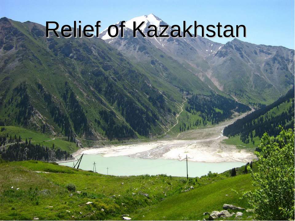
Relief of Kazakhstan
 Plateau (Ustyurt, Turgay, Pre-Ural) Mountains (Altai,")
Plan: Lowlands (West-Siberian, Turan, Caspian) Plateau (Ustyurt, Turgay, Pre-Ural) Mountains (Altai, Saur-Tarbagatay, Tien-Shan)

The surface of the territory of the Kazakhstan is divided into 2 parts: large – lowlands and plateau (west, north and central KZ), small – high mountains (east and south-east). The surface has a slope from south-east to north-west. The structure of a surface has the large meaning for economic activity of the population: 1) The lowlands, plains and intermountain valleys are most useful for agriculture. 2) The mountain slopes covered with rich vegetation are perfect pastures for cattle.

Western, northern and central part of the territory of Kazakhstan are occupied with 3 lowlands: West-Siberian, Turan and Caspian.
 lowland The relief of the West-Siberian lowland is monotonous. Only")
West-Siberian (North-Kazakhstan) lowland The relief of the West-Siberian lowland is monotonous. Only in some places there are chains of small lakes. This lowland has a slope from the south to the north. In the south it is 200 m above the sea level, an in the north only 100.

Turan lowland Turan lowland is located in south and south-west of the republic. It raises in the south on 200 m. In north and the south of lowland it’s broken with sand deserts.

Caspian lowland The relief of Caspian lowland is monotonous. It consists of clay plains and sandy files. On the West from the river Ural there are sand-markets.

The territory of Kazakhstan is rich with plateaus. The biggest of them are: Ustyurt, Turgay, Pre-Ural.

Plateau Ustyurt Plateau Ustyurt is between the Ural and Caspian seas. It’s average height is 200 m above the sea level. It is combined from thickness clay, sandstone and limestone.

Turgay plateau Turgay plateau is located to the east f Mugodzhary. It’s average height above the sea level is 100 m. It connects with West-Siberian lowland.

Pre-Ural plateau Pre-Ural plateau lays between the Caspian lowland and Mugodzhary. It’s average height above the sea level is about 300 m. It consists of limestone, chalk and is watering by river Emba.

There are 3 mountain ranges on the territory of Kazakhstan: Tien-Shan, Altai, Saur-Tarbagatay.

Saur-Tarbagatay Saur-Tarbagatay is 2 mountain ranges together: Saur and Tarbagatay. It consists of clay, crystal schist, granite and limestone. It is located between Alakol basin in the north and river Orin in the south.

Altai Altai is divided into 3 ranges: Southern, Central and Kolbinsky. There are glaciers and hollows, deposits of polymetal ores. Altai consists from gneisses, crystal schist, marble and limestone.

Tien-Shan Tien-Shan mountains occupies the south-east of Kazakhstan. In the Central part of Tien-Shan is the highest point – Khan Tengri (6999 m).

THE END